


# Wildfire Tracker+ API v1
The wildfire tracker+ API provides ongoing wildfire updates for the areas of interest you define.
We offer 2 main products:
- Area Monitoring
- Precision Tracking
# Area Monitoring
# Active Fire
The Active Fire Area Monitoring API allows you to get all the active fires’ information within any of your predefined areas of interest, worldwide. Fires are considered ‘active’ based on accumulation of data from the last 72 hours. The predefined areas of interest are defined at the contract level, meaning you will be required to contact your account manager in order to change those areas.
# Request Parameters
An API request returns the active fires within the predefined areas of interest, including fires that intersect the boundaries. Your API key ensures that all the fire information that is relevant to the predefinition will be given via the response.
https://api.breezometer.com/fires/v1/area-monitoring/active?key={YOUR_API_KEY} While making an API request some parameters are required while some are optional.
| Parameter | Type | Description | R/O |
|---|---|---|---|
| key | String | Your BreezoMeter API key 90 | Required |
| features | String | Sets the data fields returned by the response. Possible values: See Features List below Note: You must separate every two features with a comma, and use the exact naming convention as shown in the possible values. Example: SourceID, SourceEventDescription | Optional |
# Example
This example shows a use case of tracking active wildfires in a predefined country- US only. In order to ensure that the key holds only the relevant area-of-interest (AoI) you will be required to contact your account manager. As long as there is at least one Active fire in the Aol, the response includes the perimeters and pertinent data of all active fires within (or intersecting) the Aol.
https://api.breezometer.com/fires/v1/area-monitoring/active?key={YOUR_API_KEY} # Response Data Fields
Active Area Monitoring API provides a list of fields for each active fire, based on the following statement: "Get all the active fires within your area of interest".
You will need to submit a single API request and supply the key to receive the following response fields.
Below you can find the default fields:
| Field Name | Type | Description |
|---|---|---|
| LastUpdated | ISO datetime | The last time the wildfire data was updated. |
| CurrentLat | Float | Current location average of latitudes (center of mass) |
| CurrentLon | Float | Current location average of longitudes (center of mass) |
| CalculatedAcres | Float | Calculated area size of the polygon, in acres. |
| MaxCalculatedAcres | Float | Maximal wildfire size throughout the last 72 hours |
| ShapeConfidence | Integer | The confidence value (1-5) represents how accurate is the shape of the wildfire. Scale: 1-worst, 5-best |
| ExistenceConfidence | Integer | Value (1-5) represents how confident are we this wildfire is real |
| CreatedOnDateTime | ISO datetime | The timestamp the wildfire first crossed the 1000 acres. |
| Country | ISO 3 letters (String) | The country containing the POO. |
| State | ISO (String) | The State alpha code identifies the state or equivalent entity at the point of origin. For Australia and USA only |
| City | String | The closest city to the incident point of origin |
| EventId | string format: nyyyy-VLLLLLLL-HLLLLLLLL-xxxxxxxx | Unique identifier for each wildfire event |
| EventName | String | Name of the closest city to the polygons' initial central location |
| EventDescription | String | Direction and distance to the closest city to the polygon's initial central location |
| geometry | Polygon / MultiPolygon (Lat / Long coordinates) | Geographic representation of the wildfire extent (boundary) in WGS84 coordinates. The latitude points for the polygons are to be specified in decimal degrees. The longitude points for the polygons are to be specified in decimal degrees. |
| DiscoveryDateTime | ISO datetime | The DateTime of the earliest hotspot detected for this event |
| InitialLat | Float | Initial location average of latitudes (center of mass). |
| InitialLon | Float | Initial location average of longitudes (center of mass) |
For the list of the data fields returned with each feature, see Features List
# Request-Response Example
This example shows a use case of all the active wildfires for a predefined area of interest: the US.
The request for active wildfires using this key allows clients to get all the relevant fire information for this area and only for it. Within the response, it is possible to notice cases when a local source data enrichment is available. When the data is not available the field is populated with a NULL value.
Request
https://api.breezometer.com/fires/v1/area-monitoring/active?key={KEY_FOR_US_DATA_ONLY}&features=SourceId,SourceEventDescription,SourcePercentContained,SourceDetailURL,SourceDetailURLName,SourceEventId,SourceInitialLatitude,SourceInitialLongitude Response
"metadata" : null , "type" : "FeatureCollection" , "id" : "0" , "type" : "Feature" , "CalculatedAcres" : 556.8499244610919 , "City" : "LOCUST GROVE" , "Country" : "USA" , "CreatedOnDateTime" : "2022-09-16T19:00:00Z" , "CurrentLat" : 36.34720659670154 , "CurrentLon" : -95.01901202995886 , "DiscoveryDateTime" : "2022-09-16T17:05:05Z" , "EventDescription" : "Fire is located 26 Km North East of LOCUST GROVE" , "EventId" : "2022-N3635340-W09502341-deZMTFJRI4" , "EventName" : "LOCUST GROVE" , "ExistenceConfidence" : 4 , "InitialLat" : 36.353399040512144 , "InitialLon" : -95.02340689257016 , "LastUpdated" : "2022-09-17T08:09:00Z" , "MaxCalculatedAcres" : 1614.498880183624 , "ShapeConfidence" : 1 , "SourceDetailURL" : null , "SourceDetailURLName" : null , "SourceEventDescription" : null , "SourceEventId" : null , "SourceId" : null , "SourceInitialLatitude" : null , "SourceInitialLongitude" : null , "SourcePercentContained" : null , "State" : "OK" } , "type" : "Polygon" , } } , "id" : "1" , "type" : "Feature" , "CalculatedAcres" : 112.14331772949333 , "City" : "MADERA" , "Country" : "USA" , "CreatedOnDateTime" : "2022-08-12T20:00:00Z" , "CurrentLat" : 37.63443280766591 , "CurrentLon" : -119.51986142276459 , "DiscoveryDateTime" : "2022-08-11T08:52:00Z" , "EventDescription" : "Fire is located 112 Km North East of MADERA" , "EventId" : "2022-N3766032-W11947528-X4LKhupoZ0" , "EventName" : "MADERA" , "ExistenceConfidence" : 5 , "InitialLat" : 37.66395545792201 , "InitialLon" : -119.46847306833725 , "LastUpdated" : "2022-09-17T21:12:00Z" , "MaxCalculatedAcres" : 9704.161785027458 , "ShapeConfidence" : 2 , "SourceDetailURL" : "https://inciweb.nwcg.gov/incident/8332/" , "SourceDetailURLName" : "InciWeb" , "SourceEventDescription" : "SOUTHERN SECTION OF YOSEMITE NP NEAR GREY PEAK" , "SourceEventId" : "1e643c3b-3be4-4669-892b-cf82b46fa820" , "SourceId" : "IRW_NIFC_USA" , "SourceInitialLatitude" : 37.66138 , "SourceInitialLongitude" : -119.4713 , "SourcePercentContained" : 100 , "State" : "CA" } , "type" : "Polygon" , } } , "id" : "31" , "type" : "Feature" , "CalculatedAcres" : 1863.83489866134 , "City" : "ROCKSPRINGS" , "Country" : "USA" , "CreatedOnDateTime" : "2022-09-18T15:00:00Z" , "CurrentLat" : 30.177708625793446 , "CurrentLon" : -100.17260742187501 , "DiscoveryDateTime" : "2022-09-18T13:45:05Z" , "EventDescription" : "Fire is located 21 Km North of ROCKSPRINGS" , "EventId" : "2022-N3017771-W10017261-0R1l4ea5x5" , "EventName" : "ROCKSPRINGS" , "ExistenceConfidence" : 0 , "InitialLat" : 30.177708625793446 , "InitialLon" : -100.17260742187501 , "LastUpdated" : "2022-09-18T13:45:05Z" , "MaxCalculatedAcres" : 1863.83489866134 , "ShapeConfidence" : 0 , "SourceDetailURL" : null , "SourceDetailURLName" : null , "SourceEventDescription" : null , "SourceEventId" : null , "SourceId" : null , "SourceInitialLatitude" : null , "SourceInitialLongitude" : null , "SourcePercentContained" : null , "State" : "TX" } , "type" : "Polygon" , } } ] } , "error" : null }# Visualization
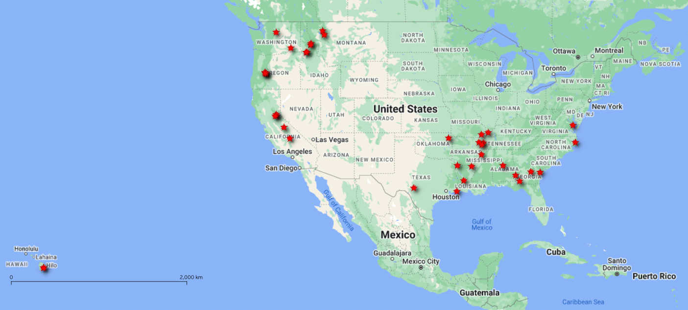
These visualizations allow you to see all the active wildfire polygons using a GIS tool to demonstrate how an API response can be used.
TIP
Note:
These APIs do not provide any visualizations.
The example shown below demonstrate a common usage of the products
Example 1: Macro view of all the active wildfires at a given moment
Example 2: Micro view of a single fire perimeter
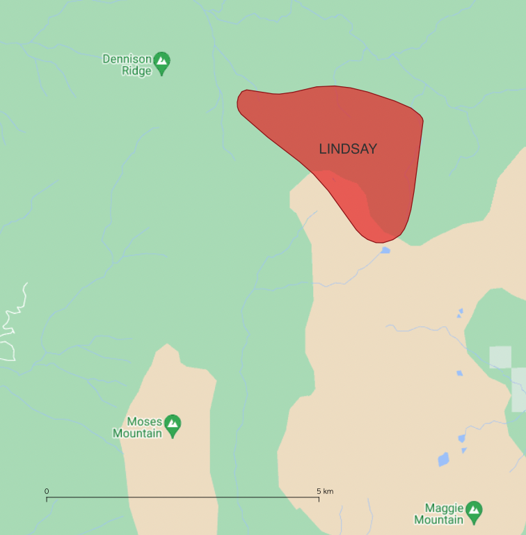
The images above used the following request-response from the Active Area Monitoring API. It is highly recommended to use colors that represent active fires for visualization purposes.
# Features List
You will get a list of all the active fires within your AoI, and receive in-depth information about each wildfire area boundaries, distance, fire name, start date and size.
Here are the various supported features:
| Field Name | Type | Description |
|---|---|---|
| SourceCurrentLatitude | Float | The current point location latitude indicated by the source |
| SourceCurrentLongitude | Float | The current point location longitude indicated by the source |
| SourceDetailURL | String (link) | Link to a specific page for the wildfire. Could be a link from the same source as ‘SourceName’ or a different one |
| SourceDetailURLName | String | The name of the local source providing the ‘SourceDetailURL’ link. Same terminology as ‘SourceName’. |
| ComplexName | String | The name of the complex where this wildfire is located |
| SourceId | String | A consistent identifier for the source agency. E.g “IRW_USA” |
| SourceName | String | The organization providing authoritative wildfire information E.g ‘IRWIN’ |
| SourceURL | String | General web address for wildfireAgencyName (the wildfire authority for a unique event) |
| SourceEventId | String | Unique identifier assigned to each wildland wildfire by the local source |
| SourceEventName | String | The name assigned to an incident by the local source |
| SourceEventDescription | String | General description of the incident given by the local source |
| SourceLastUpdated | ISO datetime | Date/time that the Agency Incident record was last modified |
| SourceDiscoveryDateTime | ISO datetime | The date and time a wildfire was reported as discovered or confirmed to exist. May also be the start date for reporting purposes |
| SourceCreatedOnDateTime | ISO datetime | Date/time that the Local source Incident record was created. |
| SourcePercentContained | Float | The wildfire containment %, provided by the local source |
| SourceContainmentForecast | ISO datetime | Expected containment date |
| SourceInitialLatitude | Float | Initial latitude value for the wildfire given by the local source |
| SourceInitialLongitude | Float | Initial Longitude value for the wildfire given by the local source |
| SourcePrescribed | Bool | When wildfires are reported as ‘prescribed’ by the local sources (if local sources provide this information) |
TIP
Note:
There are two separate endpoints for area monitoring.
One endpoint for active fires, which is available now, and one for burnt areas, which will be available soon.
Once the Burnt Area endpoint will be ready, please make sure your key is permitted to call the end point of Burnt Area Monitoring:
https://api.breezometer.com/fires/v1/area-monitoring/burnt?key={YOUR_API_KEY} # Precision Tracking
# Active Fire
The Active Fire Precision Tracking solution allows you to pull updates on-demand without being limited to certain areas. As the fires move, so does the perimeter track, ensuring a timely and updated solution you can trust.
# Request Parameters
Returns active wildfire conditions for a specific location
https://api.breezometer.com/fires/v1/locate-and-track?key=YOUR_API_KEY&lat={latitude}&lon={longitude}&radius={radius} While making an API request some parameters are required while some are optional.
| Parameter | Type | Description | R/O |
|---|---|---|---|
| lat | Float | Latitude (lat) specifies the north-south position of a point in a range between -90 and 90 | Required |
| lon | Float | Longitude (lon) specifies the east-west position of a point in a range between -180 to 180 | Required |
| radius | Integer | Desired radius from the location provided (lat, lon) Radius range: Min Value: 5 KM / 3 Mile Max Value: 100 KM / 62 Mile Note:
| Required |
| key | String | Your BreezoMeter API key | Required |
| units | String | Sets the response measurement system to either:
| Optional |
| features | String | Sets the data fields returned by the response. Possible values: See Features List below Note: You must separate every two features with a comma, and use the exact naming convention as shown in the possible values. Example: CalculatedAcres, SourcePercentContained, CreatedOnDateTime | Optional |
# Example
A request to get the status of all the current wildfires within a designated radius (20 km) of the specified location (48.857456, 2.354611) using the default request parameters settings.
https://api.breezometer.com/fires/v1/locate-and-track?key=YOUR_API_KEY&lat=48.857456&lon=2.354611&radius=20 # Response Data Fields
Precision Tracking solution provides a list of response fields for each wildfire, based on the following statement: "Get all the fires around your chosen objects".
You will need to submit a single API request and supply the object's input to receive the following response fields (included by default with all packages):
# Features List
Using the Precision Tracking solution, you will receive a comprehensive list of all the active wildfires in the specified radius, along with detailed information about their boundaries, distance, fire name, start date, and size.
Here are the various supported features:
# Confidence & Polygon
| Field Name | Type | Description |
|---|---|---|
| ShapeConfidence | Integer | The confidence value (1-5) represents how accurate the shape of the wildfire is. Scale: 1-worst, 5-best |
| geometry | Polygon / MultiPolygon (Lat / Long coordinates) | Geographic representation of the wildfire extent (boundary) in WGS84 coordinates. The latitude points for the polygons are to be specified in decimal degrees. The longitude points for the polygons are to be specified in decimal degrees |
| CalculatedAcres | Float | Calculated area size of the polygon, in acres. |
| MaxCalculatedAcres | Float | Maximal wildfire size throughout the last 72 hours |
| ExistenceConfidence | Integer | GValue (1-5) represents how confident are we this wildfire is real |
# Location
| Field Name | Type | Description |
|---|---|---|
| InitialLat | Float | Initial location average of latitudes (center of mass) |
| InitialLon | Float | Initial location average of longitudes (center of mass) |
| CurrentLat | ISO 3 letters (String) | Current location average of latitudes (center of mass) |
| CurrentLon | Float | Current location average of longitudes (center of mass) |
| Country | ISO 3 letters (String) | The country containing the POO |
| State | ISO (String) | The State alpha code identifies the state or equivalent entity at the point of origin. For Australia and USA only |
| City | String | The closest city to the incident point of origin |
# Date & Time
| Field Name | Type | Description |
|---|---|---|
| CreatedOnDateTime | ISO datetime | The timestamp of the wildfire first crossed the 1000 acres |
| LastUpdated | ISO datetime | The last time the active wildfire data was updated |
| DiscoveryDateTime | ISO datetime | The DateTime of the earliest hotspot detected for this event |
# Source Data Enrichment
| Field Name | Type | Description |
|---|---|---|
| SourceCurrentLatitude | Float | The current point location latitude indicated by the source |
| SourceCurrentLongitude | Float | The current point location longitude indicated by the source |
| SourceDetailURL | String (link) | Link to a specific page for the wildfire. Could be a link from the same source as ‘SourceName’ or a different one |
| SourceDetailURLName | String | The name of the local source providing the ‘SourceDetailURL’ link. Same terminology as ‘SourceName’. |
| ComplexName | String | The name of the complex where this wildfire is located |
| SourceId | String | A consistent identifier for the source agency. E.g “IRW_USA” |
| SourceName | String | The organization providing authoritative wildfire information E.g ‘IRWIN’ |
| SourceURL | String | General web address for wildfireAgencyName (the wildfire authority for a unique event) |
| SourceEventId | String | Unique identifier assigned to each wildland wildfire by the local source |
| SourceEventName | String | The name assigned to an incident by the local source |
| SourceEventDescription | String | General description of the incident given by the local source |
| SourceLastUpdated | ISO datetime | Date/time that the Agency Incident record was last modified |
| SourceDiscoveryDateTime | ISO datetime | The date and time a wildfire was reported as discovered or confirmed to exist. May also be the start date for reporting purposes |
| SourceCreatedOnDateTime | ISO datetime | Date/time that the Local source Incident record was created. |
| SourcePercentContained | Float | The wildfire containment %, provided by the local source |
| SourceContainmentForecast | ISO datetime | Expected containment date |
| SourceInitialLatitude | Float | Initial latitude value for the wildfire given by the local source |
| SourceInitialLongitude | Float | Initial Longitude value for the wildfire given by the local source |
| SourcePrescribed | Bool | When wildfires are reported as ‘prescribed’ by the local sources (if local sources provide this information) |
# Event
| Field Name | Type | Description |
|---|---|---|
| EventId | String format:yyyy-VLLLLLLL-HLLLLLLLL-xxxxxxxx | Unique identifier for each wildfire event |
| EventName | String | Name of the closest city to the polygons' initial central location |
| EventDescription | String | Direction and distance to the closest city to the polygon's initial central location |
# Unit Systems
This table lists the Precision Tracking fields and the units in which they are measured or calculated according to the Metric and the Imperial systems.
TIP
Note:
By default, requests return Metric measurement. Requests can be customized by setting the request’s units parameter.
| Field/units | metric | imperial |
|---|---|---|
| radius | km | mi |
# Burnt Area
The Burnt Area Precision Tracking solution allows you to get all burnt areas surrounding a given location within a certain radius.
# Request parameters
Returns the burnt areas for a specific location, in accordance with a lookback window. With the lookback window, you can choose the amount of time past the fire extinguished time, either in days or hours.
https://api.breezometer.com/fires/v1/burnt-area?key=YOUR_API_KEY&lat={latitude}&lon={longitude}&radius={radius}&daysFromExtinguish={days} While making an API request some parameters are required while some are optional.
# Example
This example shows a use case of tracking burnt areas of an active wildfire. In order to have no burnt areas visible on the map, after the wildfire is flagged as ‘Extinguished’, set up the daysFromExtinguish = 0. In practice, both active fire perimeters and their burnt areas are removed together, when the fire is out.
https://api.breezometer.com/fires/v1/burnt-area?key=YOUR_API_KEY&lat=14&lon=-10.7&radius=20&daysFromExtinguish=0 # Response Data Fields
The Burnt Area Precision Tracking solution provides a list of fields for each burnt area, based on the following statement: "Get all the burnt areas around your
You will need to submit a single API request and supply the point’s input to receive the following response fields.
Below you can find the default fields
# Response Example 1
Burnt Area service as an additional service to the Active Fire Precision Tracking solution
This example shows a use case of tracking burnt areas of an active wildfire, and demonstrates the polygons of both active fire and its related burnt areas.
# Response Example 2
Burnt Area as stand-alone service
This example shows a use case of 2 wildfires for a given location with a desired radius=100 [km].
The request for daysFromExtinguish=30, allows clients to get all the burnt areas of wildfires that have been extinguished during a lookback window of the last 30 days.
# Features List
Using the Precision Tracking solution, you will receive a list of all the burnt areas within the specified radius of the designated location, and receive in-depth information about each burnt area boundaries, distance, fire name, start date and size.
Here are the various supported features:
# Burnt Area Fields
| Field Name | Type | Description |
|---|---|---|
| geometry | Geography | The burnt area geometry represents accumulated areas that got no indication of fire burning in the last 72 hours |
| BurntLat | Float | Last burnt area location average of latitudes (center of geometry's mass) |
| BurntLon | Float | Last burnt area location average of longitudes (center of geometry's mass) |
| BurntAcres | Float | The total size of the burnt areas [acres]. Accumulations are based on the geometry |
| BurntTS | Timestamp | Last timestamp the burnt area was updated |
| LastSatelliteTime | Datetime | Latest pixel acquisition time by the satellite |
| ExtinguishedTS | Datetime | The fire extinguished timestamp indicates when (at least) 72 hours have passed since the fire was burning |
# Date & Time
| Field Name | Type | Description |
|---|---|---|
| DiscoveryDateTime | Datetime | The DateTime of the earliest hotspot detected for this event |
# Location
| Field Name | Type | Description |
|---|---|---|
| InitialLat | Float | Initial location of the wildfire, average of latitudes (center of mass) |
| InitialLon | Float | Initial location of the wildfire, average of longitudes (center of mass) |
| Country | ISO 3 letters (String) | The country containing the POO |
| State | ISO (String) | The State alpha code identifies the state or equivalent entity at the point of origin *For Australia only |
| City | String | The closest city to the incident point of origin |
# Event
| Field Name | Type | Description |
|---|---|---|
| EventId | String | Unique identifier for each event |
| EventName | String | Name of the closest city to the wildfire's initial central location |
| EventDescription | String | Direction and distance to the closest city to the wildfire's initial central location |
# Source Date Enrichment
| Field Name | Type | Description |
|---|---|---|
| ComplexName | String | The name of the complex where this wildfire is located |
| SourceId | String | A consistent identifier for the source agency. E.g “IRW_USA” |
| SourceName | String | The organization providing authoritative wildfire information E.g ‘IRWIN’ |
| SourceURL | String | General web address for wildfireAgencyName (the wildfire authority for a unique event) |
| SourceEventId | String | Unique identifier assigned to each wildland wildfire by the local source |
| SourceEventName | String | The name assigned to an incident by the local source |
| SourceEventDescription | String | General description of the incident given by the local source |
| SourceLastUpdated | ISO datetime | Date/time that the Agency Incident record was last modified |
| SourceDiscoveryDateTime | ISO datetime | The date and time a wildfire was reported as discovered or confirmed to exist. May also be the start date for reporting purposes |
| SourceDetailURL | String | Link to a specific page for the wildfire. Could be a link from the same source as ‘SourceName’ or a different one |
| SourceDetailURLName | String | The name of the local source providing the ‘SourceDetailURL’ link. Same terminology as ‘SourceName’. |
| SourcePrescribed | Boolean | When wildfires are reported as ‘prescribed’ by the local sources (if local sources provide this information) |
| SourceCreatedOnDateTime | ISO datetime | Date/time that the Local source Incident record was created. |
| SourceInitialLatitude | Float | Initial latitude value for the wildfire given by the local source |
| SourceInitialLongitude | Float | Initial Longitude value for the wildfire given by the local source |